


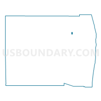
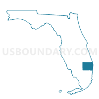
6052-Voting District, Palm Beach County, Florida
About
Outline

Summary
| Unique Area Identifier | 557637 |
| Name | 6052-Voting District |
| County | Palm Beach County |
| State | Florida |
| Area (square miles) | 0.58 |
| Land Area (square miles) | 0.58 |
| Water Area (square miles) | 0.00 |
| % of Land Area | 100.00 |
| % of Water Area | 0.00 |
| Latitude of the Internal Point | 26.80369210 |
| Longtitude of the Internal Point | -80.21710700 |
Maps

Graphs
Select a template below for downloading or customizing gragh for 6052-Voting District, Palm Beach County, Florida


Neighbors
Neighoring Voting District (by Name) Neighboring Voting District on the Map
- 1008A-Voting District, Palm Beach County, FL
- 1009-Voting District, Palm Beach County, FL
- 1017-Voting District, Palm Beach County, FL
- 6050B-Voting District, Palm Beach County, FL
- 6054-Voting District, Palm Beach County, FL
Top 10 Neighboring County Subdivision (by Population) Neighboring County Subdivision on the Map
- Royal Palm Beach-West Jupiter CCD, Palm Beach County, FL (103,335)
- Western Community CCD, Palm Beach County, FL (29,101)